

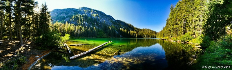
Overlooking Myrtle Lake
After hiking in approximately 4 ¼ miles to the backside of Myrtle Lake (Green Trails Map #114, trail #1404A, trailhead at the end of the Entiat River Road, outside of Entiat, Washington), this panorama presented itself with the sun setting towards the west. This image is originally composed from twenty-eight (28) photos and then cropped, taken with a vertically handheld Canon DSLR (digital single lens reflex) camera set at ISO 400 and f/8 using a wide-angle zoom lens (12 to 24). Entered into the “Nature & Landscapes” category and shared with the BetterPhoto Club: “Photographing the Northwest -- Hiking Club.”
GPS: Approximate location, latitude 48° 03' 12.73" N, longitude 120° 42' 07.52" W.
Approximate evaluation: 3,800 feet.
Keywords: Lake, Mountains, Panorama, Landscape, Nature, Trees, Water, and USA.
Uploaded on January 18, 2011