To discuss a photo, sign up as a BetterPhoto member or log in.
|
|
|
Cloud Panorama
|
|
|
|
Cloud Panorama
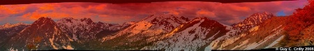
After a hard scramble of about 2 and 1/2 miles up a ridge across from the Ingalls Lake Trail (trail 1390), the following vista presented itself. To the left are the Esmeralda Peaks, in the middle is Ingalls Peak, and towards the right is Mount Stuart. This panorama is composed of 17 photos taken with a Canon 10D set at ISO 400 and f/16. After stitching the photos together, the image was transformed by using Abode PhotoShop plug-ins, primarily Flaming Pear’s. I decided to keep the remnants of the panoramic process in, because it helps one visualize the multiple photos that were part of the process and in addition creates an interesting frame. Entered into the “Nature & Landscapes” category, and shared with the BetterPhoto Club: “Photographing the Northwest -- Hiking Club”. Approximate location, latitude 47° 26' 30.00" N, longitude 120° 55' 30.00 W", at an evaluation of approximately 6,400 feet.
Guy C. Crilly |
|
|
|
|
|
|
Philippe Vieux-Jeanton |
|
Fantastic pano!! Too bad, the format here didn't translate the beauty of this image. Great work, Guy!
August 17, 2008
|
|
|
|
Log in or sign up to respond or interact.
|
